
A Journey Through Seven Distinct Regions
The trail is divided into seven regions, each offering a unique atmosphere and specific local traditions:
- Bucovina: Known for its spiritual heritage and the famous painted monasteries.
- The Upper Country (Ținutul de Sus): A wild, mountainous area with breathtaking volcanic landscapes.
- Terra Saxonum: The land of fortified churches and colorful Saxon villages.
- Terra Dacica: A region rich in ancient history, crossing the Orăștie Mountains and former Dacian capitals.
- Terra Banatica: Featuring the Banat highlands and a melting pot of diverse ethnic influences.
- Terra Romana: Following the path toward the Danube, filled with Roman vestiges.
- Cerna Valley: A spectacular finish through one of Romania’s most impressive river canyons.
An Open-Air Art Gallery
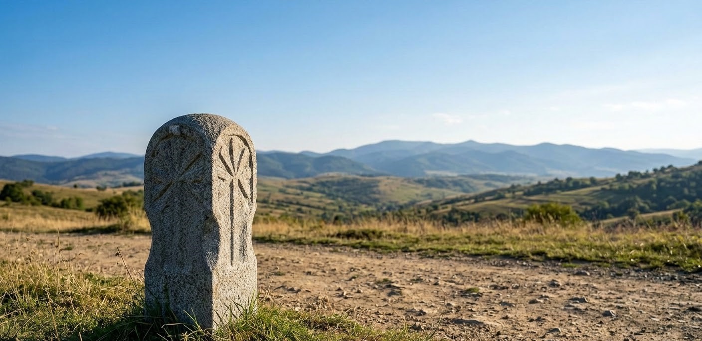
One of the most remarkable features of Via Transilvanica is its marking system. Every kilometer is marked by an individually carved andesite milestone. There are over 1,400 of these sculptures, each weighing about 250 kg and featuring a unique design created by various artists. This makes the trail not just a physical challenge, but the longest outdoor art gallery in the world.
Experience and Sustainability
Whether traveled on foot, by bicycle, or on horseback, Via Transilvanica is designed to encourage sustainable tourism. It connects over 400 local communities, offering travelers a chance to experience authentic Romanian hospitality, traditional crafts, and preserved ecosystems. It is more than just a path; it is an invitation to discover the soul of the country at a slower pace.
A superb video presenting Via Transilvanica:
Frequently Asked Questions (FAQ)
How long does it take to finish the entire trail?
The average time for a hiker is about 50 to 70 days. However, most travelers choose to hike specific sections (each taking 3–7 days) based on their time and physical condition.
Is it safe to hike alone?
While the trail is well-marked with andesite milestones and orange markings, it is recommended to hike in groups. Romania is home to a large population of brown bears and wolves, so being prepared with a whistle and bear spray is advisable.
Where do I sleep?
The trail offers various options: local guesthouses (pensiuni), forest cabins, monasteries, or even staying with locals. Camping is also an option in designated areas.
What is the "Hiker's Guide"?
It is the official guidebook (available in English) that provides detailed maps, elevation profiles, contact info for accommodation, and cultural tips for every kilometer of the journey.
Do I need a special permit?
No permit is required to hike the trail. However, you can purchase the "Hiker’s Passport" (Carnetul Drumețului) to collect stamps from various checkpoints as a memento of your journey.
Can I bike the Via Transilvanica?
Yes! While some sections are steep and rocky (better suited for mountain biking), most of the trail is accessible for cyclists.
